How to intelligently degrade or smooth GIS data (simplifying polygons)?
 https://stackoverflow.com/questions/1849928
 italiano
 english
 français
 española
 中国
中国 日本の
日本の العربية
 Deutsch
 한국어
한국어 Português
 Russian
Question
I have detailed US county maps, from the TIGER LINE data sets. How might I sample, smooth, or degrade the data so that I get straighter, more boxy, less "noisy" shapes to represent the geographical features -- in this case just county boundaries and state lines, but maybe also in the general case?
The sampling could happen at rendering time if that can be done efficiently, or a parallel data set could be generated and stored. I am using PostGIS, and the lines are multi-polylines generated by shp2pgsql -- but any solution where you take a squiggly line and reduce it to a smoother line of roughly the same significance to a human interpreter would be very useful.
Solution
The problem with simply throwing away points is that you can quickly distort the shape of the original polygon. A better approach is to come at it from the other direction; start with a basic approximation of the polygon and then refine it upwards towards your complex shape.
An excellent example of this approach is the Douglas-Puecker algorithm. You start with two vertices drawn from the full polygon. Add a third vertex by selecting the one that lies farthest from an edge drawn between the first two vertices. Continue adding points until you have something that sufficiently resembles your original polygon.
OTHER TIPS
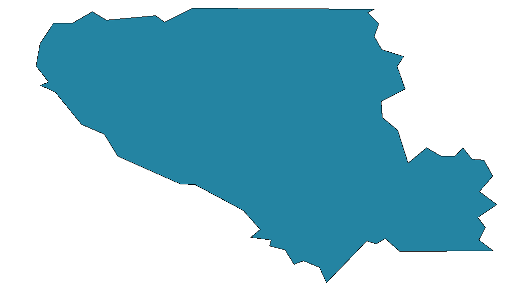
Douglas-Peucker is definitely the right approach. There are some simple ways to access implementations of it in PostGIS and QGIS that I thought I would add here for those who come across this post with a similar question. The goal is to start with something like this:
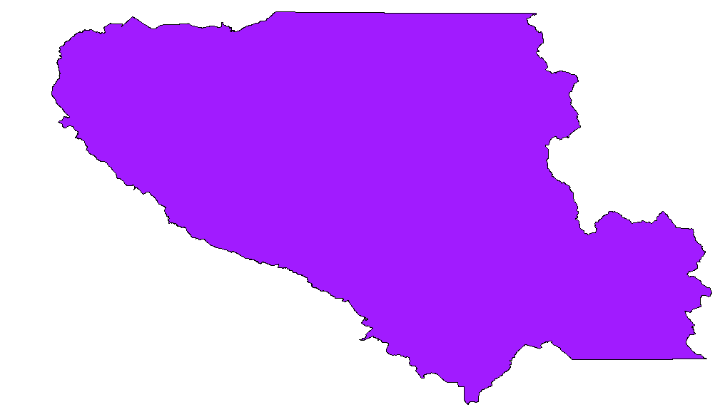
and end up with something like this:
In PostGIS Douglas-Peucker is implemented as simplify, the syntax, detailed here at bostongis.org, is some variant of:
SELECT transform(simplify(transform(the_geom, 2249), 500),4326) from the_geo_table
This worked very well even on the full national dataset, with some few errors that seem due to bad underlying data. It also turns out that in QGIS the menu item Tools > Geometry Tools > Simplify Geometries will export a simplified shapefile of any geometry and add it as a layer to your current project.
This is a pretty fundamental tool-set and I asked the question at too low a level, though it was nice to learn the underlying math, there is a good explanation of that here: http://www.mappinghacks.com/code/PolyLineReduction/, along with sample code that turns out not to be too necessary!
Instead of QGIS, I suggest using ogr2ogr because it does not delete polygons!
ogr2ogr output.shp input.shp -simplify 0.0001
Here's a simple iterative smoothing algorithm:
for each three sequential points on any path, if the middle point has no intersections and is within some small threshold angle of the direct path between the two outer points, remove it.
Repeat until satisfied.
You could also try Visvalingam’s algorithm, which iteratively removes the least perceptible part of a line. Here is a great explanation of that algorithm:
You could also use Simplify.js which uses a combination of Douglas-Peucker and Radial Distance algorithms. There are also links to many ports to other languages listed on the github project
Answer by @unmounted is correct, but I would like to add one more suggestion.
Always use function ST_SimplifyPreserveTopology instead of ST_Simplify in PostGIS. Both use the same underlying algorithm (Douglas-Peucker), but the former avoids any simplifications which would result in invalid geometries. For example, ST_Simplify may result in geometry which intersects itself.
