Perlin Noise detail level. How to zoom in on a landscape?
 https://stackoverflow.com/questions/3273880
-
17-09-2020 - |
 italiano
 english
 français
 española
 中国
中国 日本の
日本の العربية
 Deutsch
 한국어
한국어 Português
 Russian
Question
I've written my own Perlin Noise implementation and it works well. I can 'zoom' in and out by changing the frequency, but as I zoom in the noise gets smoother and smoother.
Assume I have a landscape that displays a continent. I want to zoom in down to a city-size area (or closer), but still have detail. I think I need to re-generate the landscape at the closer detail but I'm not sure if there are any implementations that can help with that?
Zoomed out, I see the continent and oceans, but I want to have large regions represented in small areas.
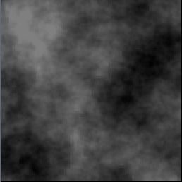
Here is an example of the problem I'm having (Continent level):

(source: blind-games.com)
Zoomed in:

(source: blind-games.com)
How can I still get rich detail when zooming in to an area on the map? Any examples of techniques involved?
Solution
You need to generate using noise at successively higher frequencies to avoid the smoothness. Try http://www.arendpeter.com/Perlin_Noise.html for a clearer explanation of how to manipulate noise frequency. Octaves naturally fit together with a level of detail (LOD) implementation, which as long as you support on the fly generation, means you only have to generate more detail as you move close to it. Be aware that there are draw backs to on the fly generation of terrain, such as complicating generation of features like rivers and roads, so you may end up with pre-generation of terrain to a fixed minimum level of detail (e.g. 64 km grid squares), and then on the fly generation of more detailed features.
I'd also recommend looking at Simplex noise which has lower computational overhead (see https://en.wikipedia.org/wiki/Simplex_noise for more details).
OTHER TIPS
Assuming that you're generating the map files statically rather than on the fly I think your simplest solution is to generate the entire map at the highest resolution you require. In effect you're then zooming out and back in to that level of granularity. It's more computationally expensive and will yield larger map files. Depending upon your implementation for the viewer you can either use one single map file or build some de-resolutioned files for the bigger view.
